As of March 2025, Dholera Special Investment Region (SIR) is gaining momentum with major developments like Tata’s semiconductor plant, Renew Power’s solar manufacturing facility, and the near-complete Ahmedabad Dholera Expressway. in this article we talk about Dholera city map and These projects position Dholera as a hotspot for real estate investment, industrial growth, and job creation, making it a trending topic for investors worldwide.
Types of Dholera Maps Available
1.Dholera City Map – A Blueprint for Smart Living
The Dholera City Map offers a detailed overview of the entire smart city, highlighting key zones and development areas. Perfect for investors and planners, this dholera town planning map showcases:
- Residential and Commercial Zones: Affordable housing, luxury townships, and commercial hubs poised for high ROI.
- Industrial Hubs: Locations for manufacturing, IT, and logistics, including Tata’s upcoming semiconductor facility.
- Green and Recreational Spaces: Sustainable parks and leisure areas promoting eco-friendly living.
- Key Amenities: Planned schools, hospitals, shopping centers, and entertainment zones for a high-quality lifestyle.

2. Dholera Gujarat Map – Connectivity at Its Core
The Dholera Gujarat Map positions Dholera within Gujarat, emphasizing its strategic location and connectivity to major cities like Ahmedabad (100 km away), Gandhinagar, and Bhavnagar. This map is essential for:
- Regional Context: Understanding Dholera’s proximity to Gujarat’s economic powerhouses.
- Transportation Hubs: Proximity to Dholera International Airport (under construction) and seaports for global trade.
- Travel Planning: Easy access via the Ahmedabad-Dholera Expressway and proposed metro connectivity.
Investor Insight: With Gujarat attracting ₹2,000-3,000 crore annually in Dholera land investments (as of late 2024), this dholera sir map with planning highlights why Dholera is a top choice for long-term growth.
dholera sir map pdf
A downloadable Dholera map PDF offers high-resolution details of the city’s layout. This is ideal for those looking for offline access to the city’s plans. You can:
- Zoom into specific regions.
- Print the map for reference during visits.
Dholera SIR Map
The Dholera SIR map focuses on the Special Investment Region. It highlights:
- Industrial Corridors: Zones for semiconductors, renewable energy (e.g., Renew Power’s 2 GW solar plant), and logistics.
- Logistic Parks: Multi-modal hubs enhancing trade along the Delhi-Mumbai Industrial Corridor (DMIC).
- Utility Infrastructure: Solar-powered grids, water treatment plants, and zero-waste systems for sustainability.
2025 Update: Recent drone surveys by Drone Acharya (March 2025) provide updated SIR layouts, ensuring precision for investors eyeing industrial plots.

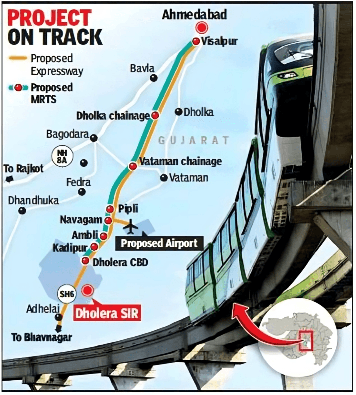
Ahmedabad-Dholera Expressway Route Map – Speeding Up Growth
The Ahmedabad-Dholera Expressway, nearing completion in 2025, slashes travel time between Ahmedabad and Dholera to under an hour. This route map details:
- Alignment: A 6-lane expressway connecting key industrial and residential zones.
- Interchanges: Strategic entry/exit points for seamless access.
- Connectivity: Links to the DMIC and Dholera International Airport for global reach.
Investor Benefit: Faster connectivity boosts property values and accessibility, making Dholera plots a trending investment choice in 2025.
Dholera SIR Village Map
The Dholera Special Investment Region (SIR) is spread across a massive 920 km area and includes 22 villages from the Dholera sub-district.
Understanding which villages are inside the Dholera SIR and which TP Schemes (Town Planning Schemes) they fall under is the most critical step for any investor to ensure their plot is safe, legal, and primed for growth.
The 22 villages within the Dholera SIR boundary are guaranteed to benefit from the planned smart city.

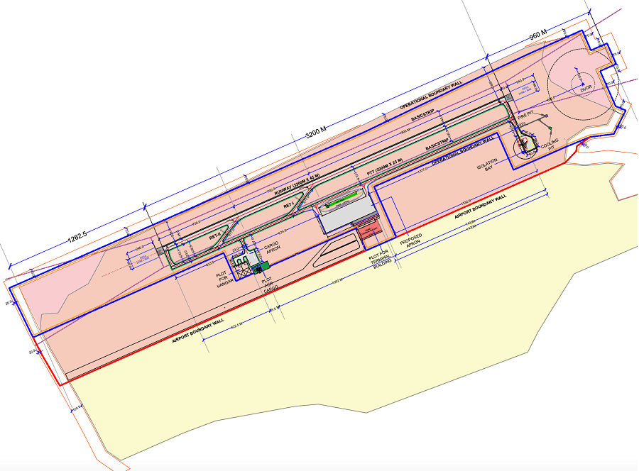
Dholera International Airport Map
The Dholera International Airport is set to become India’s largest cargo and passenger hub, acting as a global gateway for the Dholera SIR. Located near Navagam, this massive infrastructure project is designed to handle the world’s largest aircraft (Code 4E).
- Location: 80 km from Ahmedabad and 20 km from Dholera SIR Activation Area.
- Runway Capacity: Two independent parallel runways (4,000 meters) capable of handling heavy cargo.
- Connectivity: Seamlessly linked via the Ahmedabad-Dholera Expressway and the upcoming Regional Rapid Transit System (RRTS).
- Strategic Importance: It will serve as an alternative to the crowded Ahmedabad Airport, specifically focusing on the export logistics of the Tata Semiconductor Fab.
Decode the Dholera Map with an Expert
Don’t just look at the zones—understand where the true ROI lies. Stop guessing which TP Scheme is best and get a customized, data-driven investment roadmap.
- ✓ Compare TP1 vs TP2 vs TP5 for your specific budget.
- ✓ Identify high-growth Commercial & Residential corridors.
- ✓ 1-on-1 Virtual Consultation with Dholera experts.
Book Your Session
Select your investment size to get verified proposals.