If you are looking at a Dholera Town Planning (TP) map for the first time, it might look like a colorful puzzle. However, reading it is actually very easy once you know what the colors and lines mean. In Dholera, the map is your most important document. It shows you exactly what the government has planned for your land. Here is a simple, step-by-step way to read it.
How to Read a Dholera TP Map easily
Before you invest in Dholera SIR, you must know how to look at the official Town Planning (TP) Map. This map is the final word on where your land is located, what roads will touch it, and what you are allowed to build there.
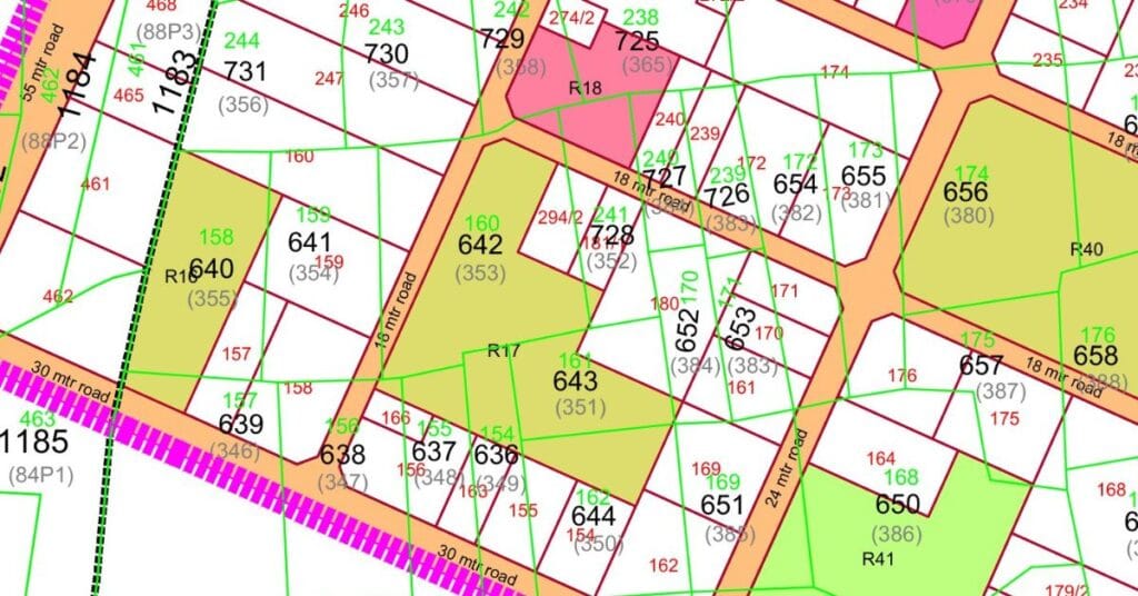
1. The Green Border: The “Original” Land (OP)
On the map, you will see many boxes with Green Borders.
- What it is: This is the Original Plot (OP). This represents the land in its old state (as per farmer records) before the smart city was planned.
- The Green Number: Inside the green border, there is a number written in Green color. This is the old survey number of that land.
2. The Red Lines & Numbers: Your “New” Land (FP)
This is the part that matters most to you. Look for the Red Outlines and Red Numbers.
- What it is: This is the Final Plot (FP). This is the actual piece of land you will own and can build on.
- The Process: Every farmer’s land (OP) has been given a new, final location (FP).
- The Black Number: Inside the green area, you will see a Black Number. This number tells you which Red Box (Final Plot) belongs to that specific green area.
Find the Black Number in the green area, then find that same number in a Red Box. That red box is exactly where your land is located now.
3. Understanding the Roads
The grey lines moving between the plots are the roads. The wider the road, the more valuable your land becomes.
- 18-Meter Road: A standard road for residential areas.
- 24-Meter Road: A bigger main road.
- 55-Meter Road: A very large, high-value road for major connectivity.
Make sure your Red Box (FP) is touching one of these roads. Land that touches a 55-meter road is usually the best for investment.
Quick Summary Checklist
Before you buy any land, open the map and check these 3 things:
- Find the Red Box: This is your Final Plot (FP).
- Match the Numbers: Does the Black number in the Green area match the Red number on the plot?
- The Road Touch: Is there a grey road line (18m, 24m, or 55m) touching your Red box?
If you have a survey number or an FP number and you are still confused, we can help. We will check the official TP map for you and show you exactly where your land is.
