
Dholera is attracting attention from land investors because of its planned industrial ecosystem, major infrastructure projects, proposed urban development and airport connectivity. However, when buying a residential plot, one important question is often overlooked:
Does the specific location offer the connectivity, infrastructure and future residential demand needed to support the investment?
A plot may be advertised as being near Dholera Smart City, close to an industrial zone or connected to the upcoming airport. But these descriptions do not automatically mean that the plot is inside Dholera Special Investment Region (SIR), that it has direct access to developed infrastructure, or that people will want to live there in the near future.
This guide examines 16 villages outside Dholera SIR based on ground observations and location-specific questions that investors should investigate before buying.
The objective is not to declare every village good or bad. It is to understand the difference between:
- Being geographically close to Dholera SIR and having practical access to it.
- Being near an industrial project and being connected to its employment and transport network.
- Being near a highway and having direct, legal highway access.
- Being close to the airport and being suitable for residential living.
- Being near a proposed development and having infrastructure available today.
- Buying land for a long-term investment and buying a plot intended for a home.
Some locations may be more suitable for long-term land holding, while others may have more practical connectivity or existing project development. In every case, the exact plot, survey number, land-use permissions, legal access and current development matter.
Important scope: This article focuses on the 17 outside-SIR villages identified for this investigation. The village locations and initial observations have been supplied from ground-level research. Distance estimates and development-related questions are treated as preliminary until supported by parcel-specific mapping, official documents or other reliable evidence.
How to Evaluate a Plot Outside Dholera SIR
Before comparing villages, investors should understand the difference between the planned Dholera region, its notified SIR boundary and the surrounding villages where private plotting projects may be marketed using the Dholera name.
The government’s Dholera development-plan material shows multiple designated land uses, including industrial, residential, logistics, agriculture, solar park, public facilities, knowledge and IT, city centre and Coastal Regulation Zone (CRZ). These categories are not interchangeable. A parcel’s actual permitted use must be checked against the applicable plan and land records. Government of India: Dholera SIR Development Plan brochure
What does proximity to Dholera SIR actually mean?
Dholera SIR is planned as a large industrial and urban development region. The first developed areas and the wider long-term plan should not be treated as if they have the same infrastructure maturity. The government’s planning material identifies different land-use zones and proposed infrastructure; the practical status of each road or facility still needs to be checked. DPIIT Dholera SIR brochure
A plot outside the SIR may benefit from nearby economic activity, but that does not automatically provide the plot with SIR infrastructure, planning permissions or direct access to an industrial estate. Buyers should evaluate the actual route and the legal status of the land they are purchasing.
Village by Village Ground Reality: 17 Villages Outside Dholera SIR
The 17 villages discussed below are outside Dholera Special Investment Region (SIR), but their connectivity, surrounding land use, infrastructure, and potential buyer demand can differ significantly. A plot closer to an SIR boundary is not automatically a better investment. The actual road route, permitted land use, project development, drainage, and distance from employment areas all matter.
The following assessment combines location-specific observations with practical checks investors should complete before purchasing land. Distances and ground observations should be verified for the specific village, survey number, and project.
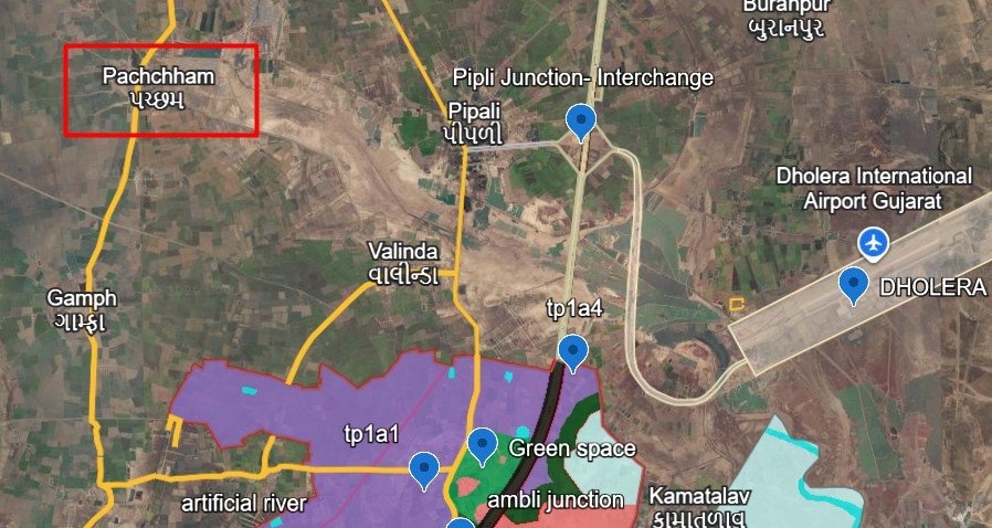
1. Pachcham Village
Ground observation: The initial assessment places Paccham approximately 14 km from the Dholera SIR boundary. A concern is that planned infrastructure and practical end-user demand may be limited compared with more connected locations.
What investors should investigate
- Confirm the distance from the exact project boundary to the SIR boundary, both as a straight line and by the usable road route.
- Identify the project’s actual approach road and whether the route is convenient in ordinary conditions as well as during the monsoon.
- Check current electricity, water supply, drainage, road surfacing, street lighting and nearby daily-use facilities.
- Ask what type of buyer would realistically purchase the plot later: a local homebuyer, a person working nearby or another long-term land investor.
Residential suitability: If a project has limited nearby facilities and requires a long drive to reach employment or essential services, it may be less practical for a household intending to build and live there soon. That is a question to verify on the ground rather than an automatic conclusion about the entire village.
Investor takeaway: Do not buy Paccham solely because a sales pitch uses the Dholera name. Compare the price with the actual road connection, current development and likely resale audience. The approximate 14 km figure should be confirmed for the exact project before publication as a measured distance.
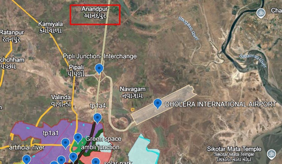
2. Anandpur Village
Ground observation: Anandpur has been identified as being near the Bhogavo River, with an estimated distance of approximately 13 km from the SIR boundary. The main concern is potential waterlogging or flooding.
What investors should investigate
- Establish the exact distance between the project and the river, its banks, canals and natural drainage paths.
- Check land elevation relative to nearby roads, agricultural fields and drainage channels.
- Visit after significant rainfall, if possible, and speak to multiple local residents about recurring waterlogging.
- Look for raised plot levels that may be higher than the surrounding land, while also checking where stormwater is intended to drain.
- Confirm whether the layout has a functioning drainage plan and a reliable access road during the monsoon.
Important distinction: Being near a river does not by itself prove that a plot floods. Likewise, a dry site on the day of a visit does not prove that it is flood-safe. The precise elevation, drainage system, river behaviour and history of the specific parcel matter.
Residential suitability: A family considering a permanent home needs confidence that the approach road, plot and surrounding area remain usable through the wet season.
Investor takeaway: Treat drainage and waterlogging as priority due-diligence questions in Anandpur. Do not describe the village or a particular project as flood-prone without supporting evidence.
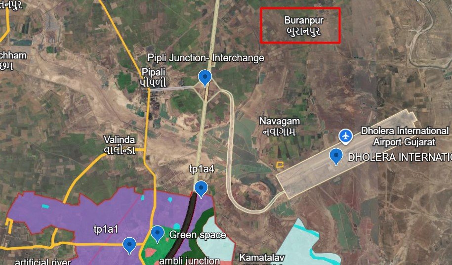
3. Buranpur Village
Ground observation: The preliminary estimate places Buranpur approximately 14 km from the SIR boundary. The main concern is whether the present infrastructure and residential demand justify buying a plot there.
What investors should investigate
- Measure the route from the actual project to the SIR boundary and relevant developed access points.
- Check whether the project connects to a usable main road or relies on internal village roads.
- Confirm the presence and condition of water, electricity, drainage and other basic services.
- Look for completed houses, occupied homes and active local businesses rather than relying only on plot markers or project boards.
- Ask local brokers and residents about actual resales, completed transactions and the kinds of buyers who are active in the area.
Residential suitability: A location with limited services may be suitable for a patient long-term investor but less convenient for someone intending to build immediately. Whether that is true in Buranpur must be determined from the project’s present condition.
Investor takeaway: Do not confuse distance from the SIR boundary with access to employment or developed urban services. Verify the actual route, facilities and buyer demand before deciding whether the asking price compensates for the waiting period.
4. Kamiyala Village
Ground observation: Some projects are marketed as being near the Pipli–Fedra highway, but the concern is that the actual plots may lie behind the village and require travel on internal roads rather than directly touching the highway.
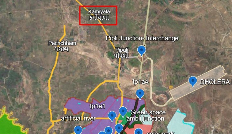
This distinction is important. A project can be described as “near the highway” even when it does not have direct highway frontage.
What investors should investigate
- Open the exact project pin in Google Maps and compare it with the highway alignment.
- Drive from the highway to the project entrance and record the full route.
- Check the width, surface, ownership or public status, and year-round usability of the connecting road.
- Confirm whether the project has legally usable access and whether any proposed access road is already available.
- Avoid paying a highway-frontage premium unless the plot’s actual position and access support it.
Residential suitability: The practical question is not only how close the project is to the highway, but whether a resident can conveniently and safely reach it every day.
Investor takeaway: For Kamiyana, the difference between direct highway access and a village-road approach should be clearly shown in any investment comparison. A map pin, a road sign or a sales brochure is not sufficient proof of direct access.
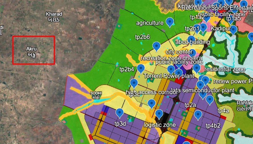
5. Akru Village
Ground observation: Akru has been identified among the Dhandhuka-side locations marketed under the wider Dholera investment story. A concern is that some projects may be near land described as green-zone land.
What investors should investigate
- Obtain the exact survey number and overlay it on the applicable development and land-use maps.
- Confirm whether the project itself is outside the SIR boundary, as identified in this investigation, and whether it is agricultural land, converted land or another category.
- Establish whether “green zone” refers to an official designation, an informal description or a marketing claim.
- Check the current approach road, nearby facilities, existing construction and the actual distance to relevant employment centres.
- Verify the permissions required for residential construction or plotting.
Why zoning matters: A green or agricultural designation does not automatically mean that a surrounding village will never develop. However, it can affect what may lawfully be built on the particular parcel and what future changes can reasonably be assumed.
Residential suitability: Buyers should establish whether the project is legally suitable for the intended use before judging its location as good or bad.
Investor takeaway: In Akru, verify the zoning and access of the actual plot. Do not rely on a broad statement that a project is near Dholera or on a salesperson’s interpretation of a colour on a map.
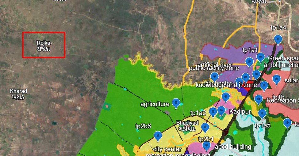
6. Rojka Village
Ground observation: Rojka is among the Dhandhuka-side villages being considered because plots in the wider region may be marketed using the Dholera name. The key issue is whether the particular project’s connectivity, zoning and development support its residential investment case.
What investors should investigate
- Identify the exact village and project boundaries; do not rely on the village name alone.
- Confirm whether the project lies near a green-zone boundary and check the official designation of the parcel.
- Measure the actual road distance to the SIR boundary, the relevant industrial access point and major roads.
- Check whether basic services and occupied residential development are present.
- Compare the asking price with similar plots having comparable legal status, road access and development.
Residential suitability: A lower purchase price may appeal to an investor who can hold the land for years. However, if local facilities are limited and the future buyer pool is narrow, resale may take longer than expected.
Investor takeaway: Rojka should be evaluated on current access, the exact land-use category and evidence of demand—not just its association with the wider Dholera growth story.
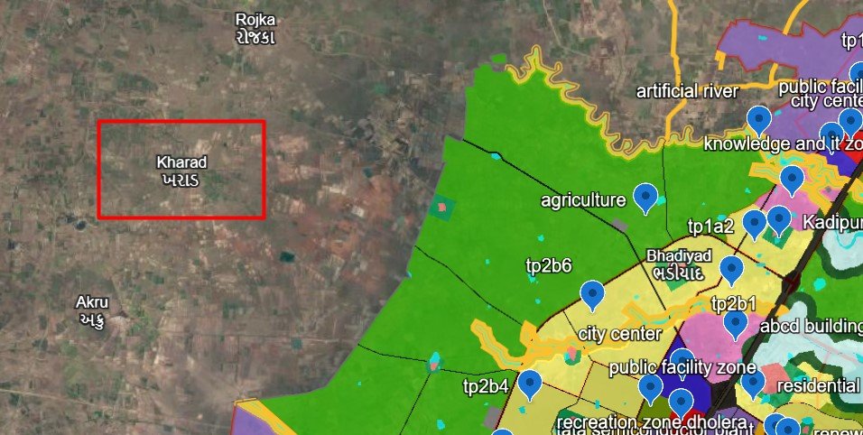
7. Kharad Village
Ground observation: Kharad is another Dhandhuka-side location included in the research. The main investor question is whether a lower-priced plot, if offered, compensates for the actual distance, access and development conditions.
What investors should investigate
- Verify the project’s survey number and legal title.
- Record the actual route from the plot to the highway and the relevant SIR access point.
- Inspect road condition, drainage, electricity, water availability and nearby occupied homes.
- Confirm the land-use designation and the permissions required for the intended use.
- Ask for evidence of actual resale transactions rather than relying only on advertised prices.
Why a cheaper plot is not automatically a better investment: A low entry price may reflect distance from facilities, a weaker resale market, limited legal permissions or a longer wait for development. It may also simply reflect differences in parcel size or documentation. The reason needs to be established.
Residential suitability: If a buyer intends to build a home soon, present-day access and services matter more than a general promise of future development.
Investor takeaway: Kharad should be assessed on the total cost, legal usability and realistic resale options. A low price alone is not proof of value.
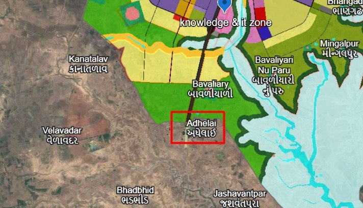
8. Adhelai Village
Ground observation: Adhelai has been identified as a location near the Phase 3 / TP6 side of the wider Dholera planning area. The main question is how its practical connectivity compares with the earlier-developed industrial and employment areas associated with Phase 1.
What investors should investigate
- Confirm the exact project location and the actual route to the relevant SIR access point.
- Check whether the road is existing and usable or proposed in a development plan.
- Compare the route to industrial employment areas with the route to the airport and expressway.
- Check current development, facilities, drainage and the project’s legal access.
- Establish whether the plot’s intended use is permitted and whether the project has the required approvals.
Why the phase distinction matters: A location associated with a later development area may have a different timeline from one connected to infrastructure that is already operational. Being close to a planned boundary does not prove that nearby roads, utilities or employment opportunities are ready today.
Residential suitability: For someone planning to build a home soon, the current journey to work, access to services and day-to-day convenience should be prioritised. A long-term investor may assess future connectivity differently, but must accept uncertainty about timing.
Investor takeaway: Adhelai needs a practical route-and-infrastructure assessment. Avoid treating the label “near Phase 3” as proof of immediate residential demand.
9. Kamatalav Village
Ground observation: Kamatalav has been described as touching the Dholera SIR boundary near the solar-park area. Concerns include its low-lying character, possible waterlogging, proximity to a CRZ area and the type of development that may eventually occur nearby. Airport proximity may be an advantage.
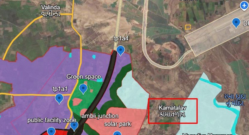
These are important questions, but they need to be separated into distinct checks.
A. Solar-park adjacency
The Dholera development-plan material identifies a solar-park land-use category. That does not establish that every parcel adjoining it will be developed exclusively for solar use, or that no other infrastructure will ever be constructed nearby. The official map and the exact boundary must be checked.
Investors should ask:
- Is the project adjacent to the designated solar-park zone or merely being marketed as nearby?
- What land use applies to the plot itself?
- What existing road, electricity and water infrastructure is available?
- What evidence exists of actual construction or an approved development programme in the immediate surroundings?
B. Low-lying land and waterlogging
The concern about water accumulation should be investigated through site elevation, drainage routes, local rainfall history and observations from residents. Visit after heavy rain if possible. Inspect whether the project is higher or lower than the surrounding fields and roads.
Do not assume that all low-lying land floods, but do not dismiss the risk because a site looks dry during a visit.
C. Coastal Regulation Zone (CRZ)
The Dholera development plan identifies CRZ as a distinct category. However, proximity to a coastal zone is not enough to determine whether a particular survey number is restricted. The applicable Coastal Zone Management Plan and parcel location need to be checked. The government development-plan map is a starting point, not a substitute for a survey-specific regulatory assessment. DPIIT Dholera SIR brochure
D. Airport connectivity
Airport proximity may help some land uses, but the actual road route, access time and current airport status matter. Do not assume that a nearby airport immediately creates residential demand.
Residential suitability: The central question is whether the location offers a practical place to live, rather than only a future infrastructure story. If waterlogging risk is significant or nearby daily facilities are limited, those factors could outweigh the attraction of airport proximity.
Investor takeaway: Kamatalav requires careful checking of four factors together: exact zoning, low-lying land and drainage, CRZ status, and real road connectivity. Do not buy on the assumption that the solar park guarantees development or that airport proximity guarantees appreciation.
10. Kasindra Village
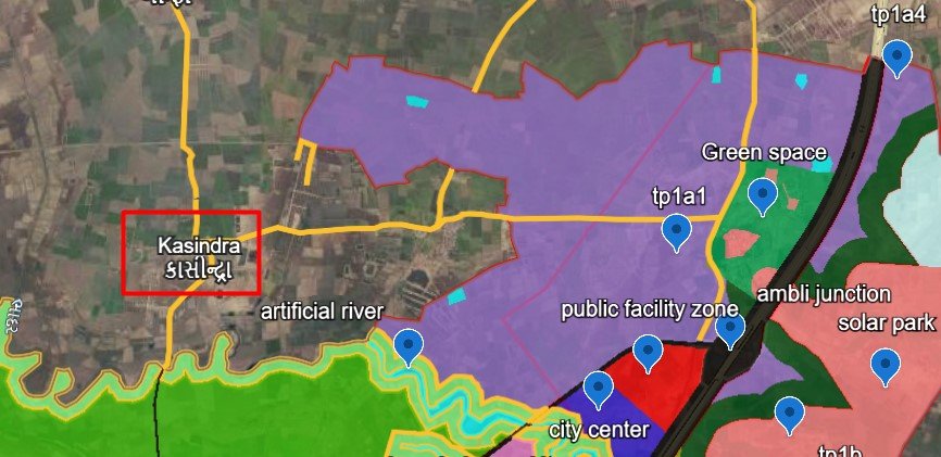
Ground observation: Kasindra has been identified as approximately 1.5–2 km from the SIR boundary. This estimate needs to be measured from the specific project rather than applied to every plot in the village.
What investors should investigate
- Confirm the project pin and survey number.
- Measure both the straight-line distance and the practical road route to the SIR boundary and relevant access points.
- Check whether the connecting road is usable, wide enough for regular traffic and available throughout the year.
- Inspect current development and essential facilities.
- Verify the land-use category, title and permissions relevant to the proposed use.
Why a short boundary distance may be misleading: A plot can be geographically close to the SIR but still require a longer journey to reach an industrial entrance or a developed urban facility. A boundary is not the same as an open access gate.
Residential suitability: A location’s usefulness for a family depends on the actual route to work, schools, healthcare, shops and other daily needs—not simply the distance printed in a brochure.
Investor takeaway: Kasindra’s reported 1.5–2 km proximity is a useful starting point. Before buying, confirm the exact route, the location of the nearest usable SIR access point and the present state of the project.
11. Gamph Village
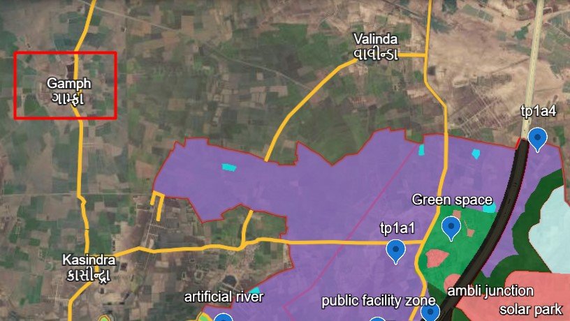
Ground observation: Gamph has been described as approximately 3 km from the SIR boundary. The reported access route does not enter the SIR directly from the village; it runs along a village road and then via Ambli to access the TP1 industrial area.
What investors should investigate
- Drive the full route from the project entrance to the actual TP1 access point.
- Record road width, road surface, turns, bottlenecks and any seasonal difficulties.
- Confirm that the route is legally accessible and not dependent on informal passage across private land.
- Check whether the road is existing or only proposed for improvement.
- Compare the project’s current development and facilities with its advertised future potential.
Why this matters: A short straight-line distance does not guarantee a convenient commute. For a household or worker, the full route and its reliability are more important than the boundary distance alone.
Residential suitability: If the road route is inconvenient or daily services are limited, the location may be less attractive to people seeking a home in the near term. That needs to be tested through on-ground observation and evidence of actual occupancy.
Investor takeaway: For Gamph, map the complete route via Ambli rather than relying on the approximately 3 km boundary estimate. The quality and reliability of the connection may be more important than the number itself.
12. Shela Village
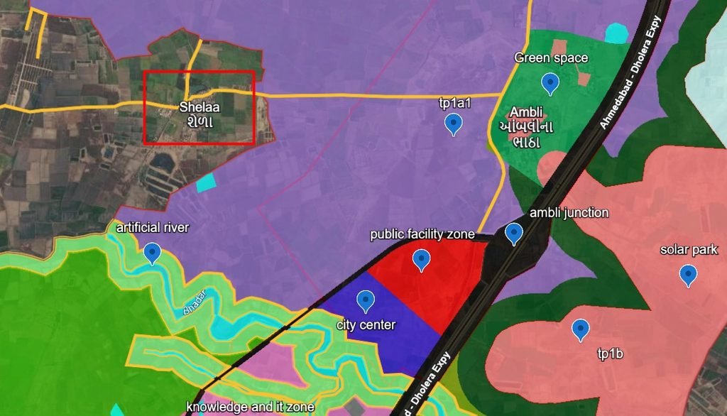
Ground observation: Shela has been described as lying along the SIR boundary, with SIR land on both sides of parts of the village. The reported connectivity includes access towards TP1 industrial areas and routes leading toward City Centre, the Public Facilities Zone, Knowledge & IT areas and the expressway. At the same time, some plotted projects may show little completed development beyond boundary markers or project boards.
Potential location advantage
If the exact project has a usable connection to the relevant SIR-side road network, that may be a practical advantage compared with a more distant location. But the precise route, legal access and present condition of the road must be verified for each project.
What investors should investigate
- Locate the actual project and confirm which side of the SIR boundary it occupies.
- Check the direct route to the relevant industrial access point and the roads connecting towards other planned facilities.
- Distinguish existing roads from proposed road connections.
- Inspect whether the project has completed internal roads, drainage, street lighting, water arrangements and electricity.
- Look for occupied homes and functioning facilities, not only plotted boundaries or sales signage.
- Confirm the legal status and approvals of the specific layout.
A crucial distinction: good location versus good project
A project may be in a relatively convenient location yet still have incomplete infrastructure, uncertain approvals or limited readiness for residential use. Conversely, a developed project in a less central location may offer better immediate living conditions. Both location and project quality must be assessed.
Residential suitability: Shela may deserve close comparison for buyers who value proximity to the SIR edge, but the decision should depend on actual access and completed development—not the village name alone.
Investor takeaway: Shela’s possible connectivity is worth investigating, but buyers should not assume that every project in the village is developed or ready to live in. The project’s current condition is as important as the map location.
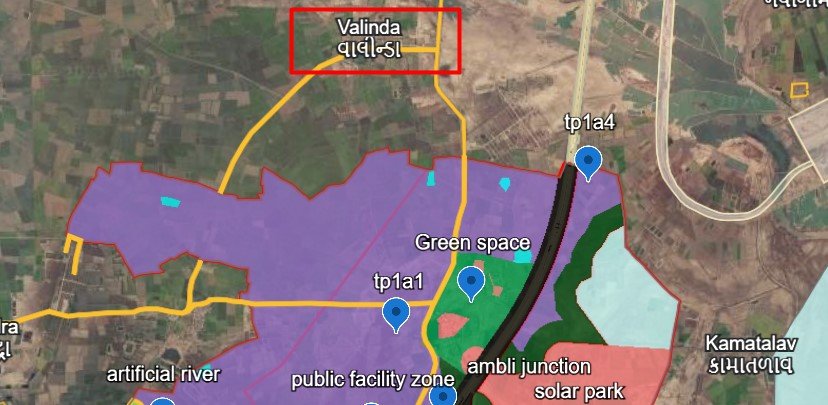
13. Valinda Village
Ground observation: Valinda has been described as being near the approach to Dholera SIR, with the SIR boundary estimated at around 2.5 km from the relevant location. The concern is that some projects are reached by village roads rather than touching the highway directly. The user’s ground observation is that completed projects have not been seen at the locations examined so far.
What investors should investigate
- Confirm the actual plot location and its distance from the SIR boundary.
- Measure the complete road route from the plot to the highway and to the relevant SIR access point.
- Check whether the project is highway-facing or reached by internal village roads.
- Inspect current internal development, road surfacing, drainage, utilities and surrounding construction.
- Confirm land-use permissions and the legal access to the plot.
Why highway proximity can be misunderstood: A village can be connected to a highway without every project in that village having direct highway frontage. The project entrance and the actual route matter.
Residential suitability: If a project has little completed development, buyers should ask whether they intend to hold the land for years or build a home soon. These are different investment decisions.
Investor takeaway: Valinda should be assessed on the actual road connection and the project’s readiness. The reported 2.5 km distance and the observation about limited completed development should be verified against the precise project being considered.
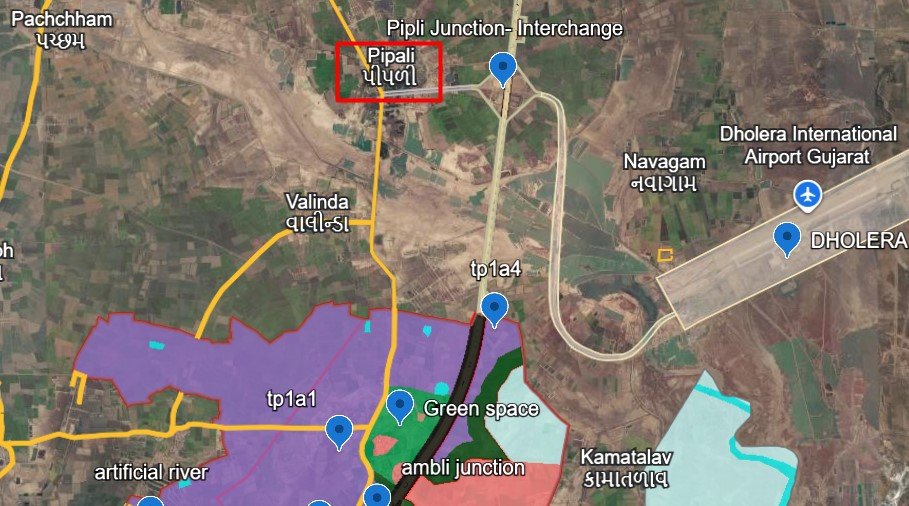
14. Pipli Village
Ground observation: The Fedra–Pipli road/highway passes through the location identified in this research. The reported advantages are direct connectivity towards Dholera SIR, the expressway and the airport. The estimated distance to the SIR boundary is around 4 km, and some projects have reportedly reached a developed stage.
Potential advantages
- The highway corridor may make access more convenient than a location that depends entirely on smaller internal roads.
- Existing project development, where confirmed, may give buyers a clearer picture of what has actually been built.
- Routes towards the SIR, expressway and airport may be useful for certain buyers and business activities.
What investors should investigate
- Confirm whether the actual plot fronts the highway or is reached by a connecting road.
- Measure the route to the SIR boundary, the relevant industrial entrance, expressway access and airport entrance.
- Inspect the completed portions of each project and distinguish operational facilities from promised amenities.
- Verify internal roads, drainage, electricity, water arrangements, title, land use and applicable approvals.
- Compare developed projects with undeveloped plots rather than treating all Pipli projects as equivalent.
Residential suitability: Highway connectivity can be helpful, but noise, road safety, traffic and the distance to everyday services should also be considered. The exact position of the plot relative to the highway matters.
Investor takeaway: Pipli is worth investigating for its reported road connectivity and the presence of some developed projects. However, the actual highway access, road route and project readiness must be confirmed before describing any particular plot as well connected or developed.
15. Navagam Village
Ground observation: Navagam has been identified as the village associated with the Dholera airport site. The possible advantage is access to airport-related economic activity. The concern is whether a location influenced by cargo operations, passenger flights, warehousing and logistics would be as attractive for residential plots.
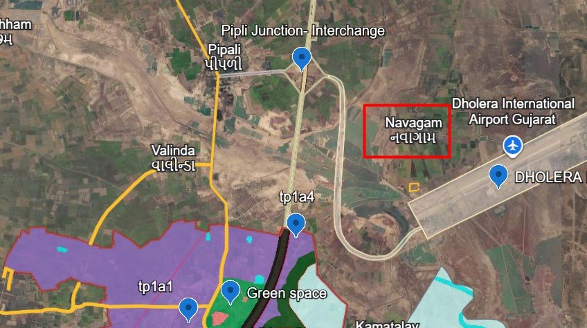
The airport is a genuine infrastructure project, but its future commercial impact on a particular plot depends on its operations, road access and surrounding land use. On 14 July 2026, India’s Ministry of Civil Aviation described Dholera Airport as under construction. Buyers should check for subsequent official updates before treating it as fully operational. Ministry of Civil Aviation: Dholera Airport progress update
Potential airport-related advantages
- Airport-related businesses may create demand for transport, logistics, storage and supporting services.
- Some locations may benefit from access to airport roads or nearby commercial activity.
- The precise type of demand will depend on actual airport operations and approved surrounding land uses.
Residential concerns to investigate
- Is the plot near a flight path, runway approach, airport boundary or future logistics area?
- What is the expected aircraft noise exposure at the specific location?
- Are heavy vehicles likely to use the approach roads serving the project?
- What land use is permitted on the plot and on adjoining parcels?
- Are residential services, schools, shops and healthcare available within practical reach?
Will people avoid living near the airport?
Not necessarily. Some people may value convenient access to employment or transport, while others may prefer to avoid aircraft noise and heavy-vehicle traffic. Residential demand cannot be predicted from airport proximity alone. Noise exposure, location, access and actual buyer preferences need to be assessed.
Investor takeaway: Navagam should be evaluated separately for residential and logistics-related uses. Airport proximity is not automatically an advantage for every plot, and the presence of an airport does not guarantee that nearby residential projects will appreciate or resell easily.
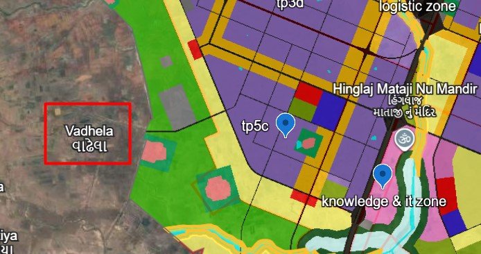
17. Vadhela Village
Ground observation: Vadhela has been identified as lying near the TP5 boundary. The current assessment is that development may take time, direct connectivity appears limited, and a green-zone designation borders the location. The concern is that these factors may make it less attractive for residential plots in the near term, although its future prospects could change.
What investors should investigate
- Confirm the exact project’s distance from TP5 and the relevant SIR access point.
- Check the official land-use designation of the plot and the adjoining green-zone area.
- Establish which access roads are usable today and whether any proposed connections have actually been constructed.
- Inspect existing development, drainage, utilities and the availability of daily services.
- Ask what practical reason a future residential buyer would have to choose this project over a better-connected alternative.
Does a nearby green zone mean development will never happen?
No. That conclusion would be too strong without checking the applicable plan and any later sanctioned changes. A green-zone designation may affect what can be built on that particular land, but it does not prove that all neighbouring land will remain undeveloped forever.
The important point is to avoid buying on the assumption that a zoning change or infrastructure extension will occur. Any such change should be treated as uncertain unless it is formally approved.
Residential suitability: Based on the current ground assessment, Vadhela appears to require a longer-term investment mindset rather than an assumption of immediate residential demand. That view should be revised if verified road improvements, permitted development or meaningful local facilities emerge.
Investor takeaway: Vadhela’s current access, zoning and development stage need to justify the price today. Future potential may exist, but it should not be used as a substitute for present-day due diligence.
How to Check Actual Road Distances Using Google Maps
For a useful village-by-village guide, each distance should be measured from the actual project entrance—not from a village centre selected at random.
Use Google Maps to compare these destinations for every project:
- Project entrance to Dholera SIR boundary
- Project entrance to the nearest practical SIR access point
- Project entrance to the relevant TP1 industrial access point
- Project entrance to the Tata semiconductor project’s actual access point, where road access information is available
- Project entrance to City Centre and the Public Facilities / Knowledge & IT areas
- Project entrance to the expressway access point
- Project entrance to the Dholera Airport entrance
How to present distances accurately
| Measurement | What it tells the investor |
|---|---|
| Straight-line distance | Geographic proximity |
| Road distance | Actual route length |
| Estimated driving time | Practical travel convenience, subject to current route conditions |
| Road type | Highway, paved village road, unpaved road or proposed road |
| Access status | Existing, restricted, proposed or unverified |
| Date checked | When the route and site condition were examined |
Do not publish a single village-wide distance when different projects within the village may have different routes. If the road is proposed rather than operational, label it clearly as proposed.
Conclusion: Invest in the Actual Location, Not Just the Dholera Name
The 17 villages in this guide show why outside-SIR plots should be evaluated individually. A location may have highway connectivity, another may be close to an industrial boundary, and another may be associated with airport or solar-park activity. Each can present different opportunities and risks.
The most important question is not simply, “How close is this plot to Dholera?”
It is:
Can this particular plot be legally used for my intended purpose, can I reach it conveniently, what development exists today, who might want to buy it later, and am I prepared for the uncertainty involved?
A disciplined investor should evaluate every project through five steps:
Investor objective → End-user suitability → Existing development → Realistic demand → Resale potential
Use the village analysis as a starting point, then verify the exact survey number, land-use designation, legal access, site conditions and current infrastructure before buying.
This guide is intended to support informed property research. It is not a guarantee of appreciation, a substitute for legal advice or a claim that every project in a particular village has the same